NASA Hydrological Forecast System Supports
Food and Water Security in Africa and Middle East

The photo shows a portion of South Africa’s Theewaterskloof Dam close to empty from drought in 2018, exposing tree stumps and sand usually submerged by the water of the dam. The Theewaterskloof Dam provides 41 percent of the water storage capacity available to Cape Town, a metropolitan area with more than 4.6 million people. Photo by Zaian and acquired from Wikimedia Commons.
Some of the most drought-vulnerable locations on Earth lie within Africa and the Middle East. To help world governments, residents, and relief organizations better prepare for droughts and related disasters, the U.S. Agency for International Development (USAID) started the Famine Early Warning System Network (FEWS NET). A recent addition to FEWS NET is the new NASA Hydrological Forecast and Analysis System (NHyFAS) for Food and Water Security Applications.
In coordination with FEWS NET, NHyFAS can provide forecasts on drought conditions and flood potential to support food insecurity early warning efforts. Researchers from NASA, other Federal Agencies, and several universities developed, tested, and put NHyFAS into production at the NASA Center for Climate Simulation (NCCS).
The underpinning software for NHyFAS (see figure below) is the Land Information System (LIS) set up to run an ensemble of land surface models (LSMs). Additional NHyFAS elements include preprocessing; spatial and temporal downscaling of seasonal climate forecasts from NASA’s GEOS global atmospheric model; data assimilation of satellite datasets, such as SMAP and GRACE; and post-processing.

This diagram highlights the new hydrological forecast system elements, which include multiple models, additional forecast features, data assimilation, and model outputs. Italicized words in the diagram indicate newer features. Figure from K.R. Arsenault et al., Bull. Amer. Meteor. Soc.
To test NHyFAS capabilities, the researchers ran 148 seasonal (6-month) hindcasts from 1981 to 2017 for Southern Africa and 480 seasonal hindcasts from 1982 to 2016 for the African and Middle Eastern continent—an area of more than 30.2 million square kilometers (11.7 million square miles). Hindcast simulations used an equivalent 27.75-kilometer (17.24-mile) resolution.
All hindcasts ran on the NCCS Discover supercomputer, with each continental simulation employing 224 processor cores. An individual LSM hindcast completed in 1 hour on average. For this work, Discover’s online disk stored 40 terabytes of input data and 6.5 terabytes of output data.
“NASA supercomputing resources made it possible to support large, multi-model, and forecast ensemble runs,” said Kristi Arsenault, data analyst in NASA Goddard Space Flight Center’s Hydrological Sciences Laboratory. “We need very robust and efficient computing capabilities to run such large domains and for multiple realizations and long-term historical runs. We also have to generate hundreds of different hindcasts to analyze the system’s skill and produce routine forecasted anomalies, like those of soil moisture, to support drought prediction.”
Impact: NHyFAS is one of the first operational, multi-model, seasonal hydrological forecast systems specifically designed to support early warning of hydrological and agricultural droughts in Africa and the Middle East. The new system plays a vital role in supporting the USAID FEWS NET’s efforts at predicting water supply deficits related to agricultural drought and food insecurity and informing humanitarian response in food-insecure regions.
Although precipitation is typically the hardest meteorological input field to forecast long term, more than 600 hindcasts demonstrated NHyFAS forecast skill—even for precipitation—to be effective for looking at drought and flood potential in areas predicted to encounter such extremes. Overall, Arsenault and collaborators found that NHyFAS captured major “categorical events” at least a few months in advance.
Building on previous forecasting efforts, “NHyFAS adds the capability to capture and predict hydrological and agricultural drought events,” Arsenault said. “In the past, most forecasts, especially for drought, focused mainly on meteorological drought indicators, which do not always reflect the timing and evolution of drought conditions from the land surface perspective. Also, we provide additional overland routed runoff and streamflow to further capture hydrological extremes, including flood potential, which can also impact crops negatively.”
Now in production at NCCS, NHyFAS seasonal forecasts are produced monthly for Africa and the Middle East using approximately 4,200 processor cores. NHyFAS forecasts have been expanded by the NASA-based FEWS NET team (Abheera Hazra, Kimberly Slinski, Amy McNally, and others) to include many more ensemble members. Among those are precipitation forecast ensemble members from the suite of North American Multi-Model Ensemble (NMME) models, which help to further improve the forecast skill. The NCCS DataPortal hosts NHyFAS forecast products for the FEWS NET partners and others to use.

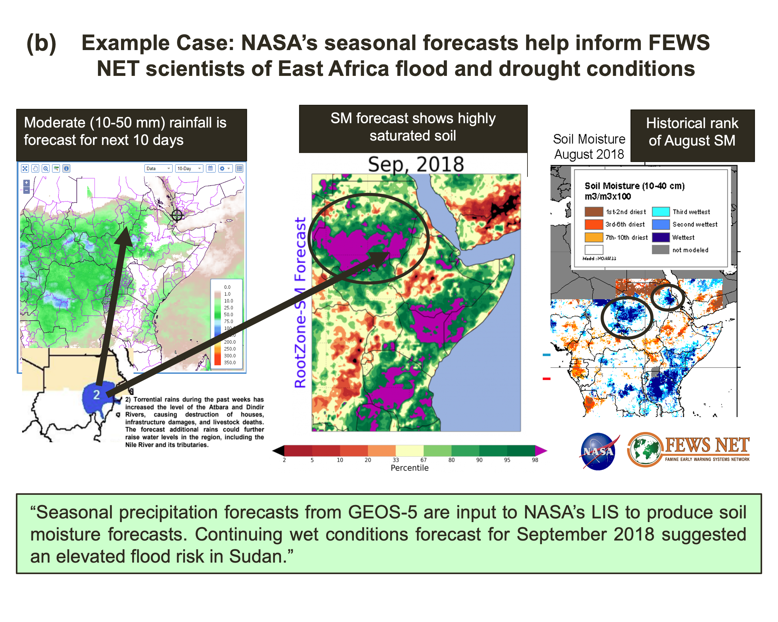
a) The top panels show an example routine NASA seasonal hydrological forecast root-zone soil moisture percentile product covering Africa and the Middle East, with (top left) July2018 initial conditions followed by the August 2018 forecast combining results from Noah-MP + CLSM model soil moisture forecasts and GEOS-V2 model seasonal forecasts.
b) The bottom panels show a real case where FEWS NET regional scientists used the September 2018 forecast month to confirm other precipitation-based forecast and preexisting wet soil conditions contributing to an elevated flood risk in Sudan.
Figure from K.R. Arsenault et al., Bull. Amer. Meteor. Soc.
Each month, NASA’s FEWS NET team provides NHyFAS seasonal forecasts of hydrological conditions over Africa and the Middle East to the FEWS NET Agroclimatology Team made up of NASA; National Oceanic and Atmospheric Administration; U.S. Geological Survey; University of California, Santa Barbara; and FEWS NET regional scientists. Arsenault explained that the partners use hydrological variables such as soil moisture and streamflow in helping to develop seasonal scenarios for agroclimatology and its impact on regional livelihoods.
“This information is then presented back to FEWS NET food security analysts at USAID’s Bureau for Humanitarian Assistance, who use it to develop food security outlooks and special alerts to support USAID decision making and inform humanitarian response in food-insecure regions,” Arsenault said. Such work can ultimately impact millions of people across the continent.
Related Links
- Arsenault, K.R., S. Shukla, A. Hazra, A. Getirana, A. McNally, S.V. Kumar, R.D. Koster, C.D. Peters-Lidard, B.F. Zaitchik, H. Badr, H.C. Jung, B. Narapusetty, M. Navari, S. Wang, D.M. Mocko, C. Funk, L. Harrison, G.J. Husak, A. Adoum, G. Galu, T. Magadzire, J. Roningen, M. Shaw, J. Eylander, K. Bergaoui, R.A. McDonnell, and J.P. Verdin, 2020: The NASA Hydrological Forecast System for Food and Water Security Applications. Bull. Amer. Meteor. Soc., 101, E1007–E1025, doi:10.1175/BAMS-D-18-0264.1.
- Shukla, S., K.R. Arsenault, A. Hazra, C.D. Peters-Lidard, R.D. Koster, F. Davenport, T. Magadzire, C. Funk, S.V. Kumar, A. McNally, A. Getirana, G. Husak, B. Zaitchik, J. Verdin, F.D. Nsadisa, and I. Becker-Reshef, 2020: Improving Early Warning of Drought-Driven Food Insecurity in Southern Africa Using Operational Hydrological Monitoring and Forecasting Products. Nat. Hazards Earth Syst. Sci., 20, 1187-1201, doi:10.5194/nhess-20-1187-2020.
Jarrett Cohen, NASA Goddard Space Flight Center