NCCS Explore/ADAPT Science Cloud Enables
Machine Learning-Based Crop Type and Yield Estimates
in Burkina Faso, West Africa

A farmer applies organic fertilizer to his maize crop in Fada N'Gourm, Burkina Faso, West Africa. Photograph by SuSanA Secretariat, cc-by-2.0, via Wikimedia Commons.
The NASA Center for Climate Simulation (NCCS) Explore/ADAPT Science Cloud enabled NASA Goddard Space Flight Center scientists and collaborators to leverage machine learning models and satellite data to predict crop type and yields in Burkina Faso, West Africa.
The computational study is part of a cooperative agreement between NASA Goddard and the Millennium Challenge Corporation (MCC), an independent U.S. foreign assistance agency focused on reducing global poverty. “One of MCC’s goals is to invest in Agricultural Development Projects, for example, irrigation, that aid farmers in developing nations to transition from subsistence farming to small-scale commercial farming,” said study leader Akiko Elders, a postdoctoral researcher in NASA Goddard’s Biospheric Sciences Laboratory. “These efforts aim to empower local farmers and combat food insecurity.”

Akiko Elders
Traditionally, MCC project data collection occurs at the field scale, but high costs limit collection frequency. “MCC strives to understand the success of their investments, such as the composition of crops grown and the degree of productivity, through these collections. Our role is to better understand how much of this information can be evaluated remotely,” Elders said.
The study region comprised approximately 2,250 hectares (5,550 acres) of irrigated cropland near the town of Di and adjacent to the Burkina Faso–Mali border (see maps below). Agriculture makes up 1/3 of Burkina Faso’s economy and employs 80 percent of its population either directly or indirectly. This land-locked country is a challenging environment for growing crops, with high average temperature and low average rainfall.

The red pin marks the town of Di, near the study region in Burkina Faso, West Africa. Map image by Google Maps.

A: The larger map shows Burkina Faso, West Africa, with the study region near the border of Mali and the town of Di traced in red (upper middle left). B: Sentinel-2 satellite imagery, acquired for September 12, 2019 (rainy season), captures the study region in greater detail. C: A further enlarged image shows cultivated plots and landscape heterogeneity within the study region. High-resolution Maxar imagery was obtained using ESRI's Basemap. Figures from Elders et al., 2022.
The study timeframe was the 2019 rainy (May to November) and dry (November to April) seasons. Remote sensing data for this period came from the European Space Agency’s Sentinel-2 satellite, available publicly from Google Earth Engine. Sentinel-2’s 10-meter resolution, multispectral data is useful for studying vegetation. For model calibration, the researchers used in-situ crop type and yield data collected in the field by Mathematica, an independent evaluator and MCC collaborator.

The study used remote sensing data from the European Space Agency (ESA) Sentinel-2 satellite to train and optimize machine learning models. Illustration by ESA.
The researchers used the satellite and in-situ data to train and optimize five Random Forest machine learning models to estimate crop type and yield across the study region. The NCCS Explore/ADAPT Science Cloud was instrumental for data storage, processing, machine learning-based analysis, and visualization.
“NCCS supercomputing resources allowed us to quickly process and analyze terabytes of moderate- and high-resolution imagery, as well as efficiently optimize our Random Forest models, which would have been limited without these computing resources,” Elders said. “In addition, this work required significant cross collaboration through shared data and software created within our research group and developed using NCCS applications.”
Impact: Understanding agricultural composition and productivity using affordable and timely remote sensing-based methods is essential for ensuring appropriate humanitarian interventions and combating food insecurity.
Model accuracy was 88% for crop type and >64% for crop yield during 2019’s rainy season and 64% for crop type and >53% for crop yield during 2019’s dry season. A unique contribution of this study was the machine learning models making interannual predictions for 2020’s dry season without training data; accuracies were up to 60% for crop type. The full results appear in the journal Remote Sensing Applications: Society and Environment.
“We leveraged machine learning models to make predictions interannually in the absence of training data,” Elders said. “The results indicate some utility in leveraging the well-calibrated Random Forest models to make skillful predictions of interannual crop type — and ultimately predict food availability for the years ahead — without training data.”
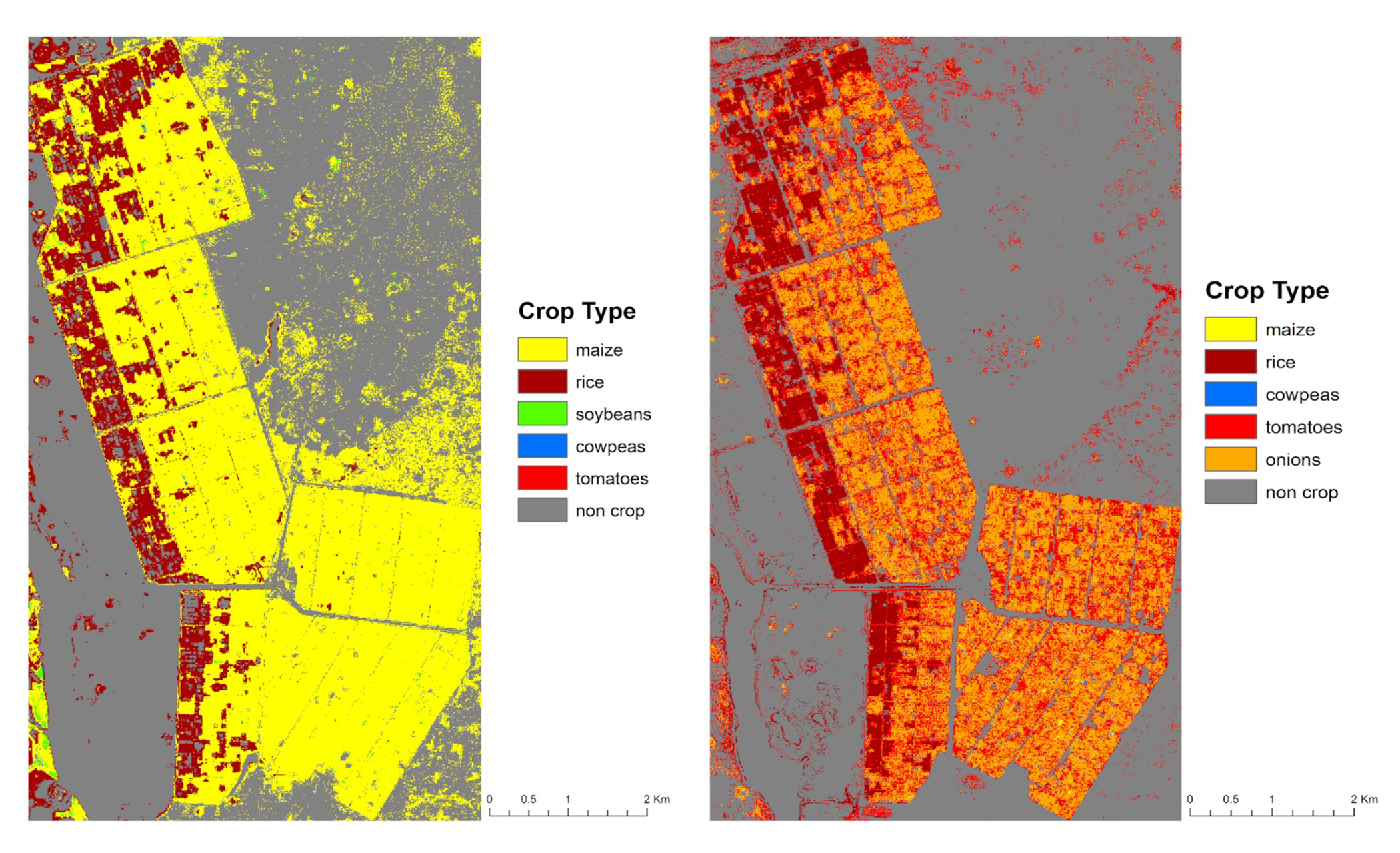
The maps show machine learning model predictions of crop type across the ~2,250-hectare (~5,500-acre) study region for the 2019 rainy (left) and dry (right) seasons. The rainy season has maize (yellow) and rice (maroon) predominating, while the dry season has onions (orange), tomatoes (red), and rice (maroon) predominating. Figures adapted from Elders et al., 2022.
Building on this study, the researchers are working on using higher-resolution datasets, Harmonized Landsat Sentinel-2 (HLS) imagery, and more complex machine learning algorithms with NCCS computing resources.
Such technical advances serve the ongoing collaboration with the federal agency MCC by having real-world decision-making applications. “This work creates a pathway to determine how productive the fields are and the extent to which farmers are adopting crops that reduce food insecurity after their MCC Agricultural Development Projects are completed,” Elders said.
Related Link
- Elders, A., M.L. Carroll, C.S. Neigh, A.L. D'Agostino, C. Ksoll, M.R. Wooten, and M.E. Brown, 2022: Estimating Crop Type and Yield of Small Holder Fields in Burkina Faso Using Multi-Day Sentinel-2. Remote Sensing Applications: Society and Environment, 27, 100820, doi: 10.1016/j.rsase.2022.100820.
Jarrett Cohen, NASA Goddard Space Flight Center
January 25, 2023