December 15, 2014
Modeling in the Field for GPM
In expeditions ranging from Arctic sea ice to Caribbean hurricanes, a host of NASA field campaigns have relied upon the NASA Center for Climate Simulation (NCCS) for real-time weather forecasts and data services. NCCS recently partnered with NASA Goddard Space Flight Center modelers to support ground- and aircraft-based campaigns for the Global Precipitation Measurement (GPM) satellite mission in two distinct regions of the United States.
GPM is a joint mission of NASA and the Japan Aerospace Exploration Agency designed for improving the accuracy, coverage, and dynamic range of precipitation measurement. Since it launched on February 27, 2014, the GPM Core Observatory has shown that its instruments can measure not only the location and intensity of precipitation but also observe transitions between precipitation types (e.g., rain to snow) from space for the first time.
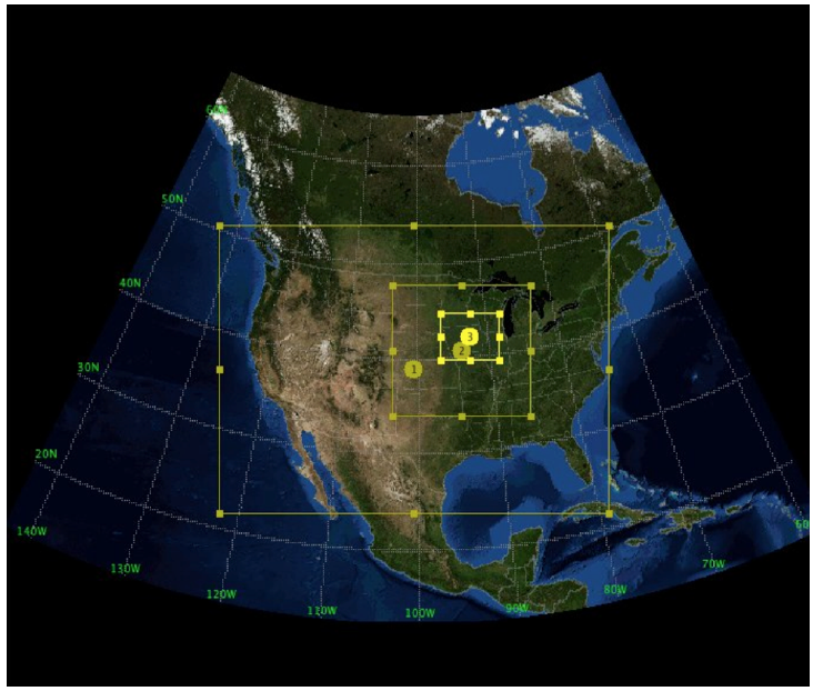
(NU-WRF) model configuration for the Iowa Flood
Studies (IFloodS) field campaign included three nested
grids with increasing resolutions: ❶ 9 kilometers (km)
for the entire U.S., ❷ 3 km for a portion of the
Midwest, and ❸ 1 km for the state of Iowa.
Satellites like GPM need field campaigns to maximize data accuracy. For new instruments, ground-based measurements help calibrate data taken from a different perspective atop the atmosphere. As part of validation, campaign aircraft carry similar instruments so scientists can compare observations of the same locations. Reliable weather forecasts are key to campaign success. “From a planning point of view, field scientists want to see what the weather will be each day,” said Di Wu, research scientist in NASA Goddard’s Mesoscale Atmospheric Processes Laboratory. “It is crucial for their decision-making.”
Wu is part of a team developing and running the NASA Unified Weather Research and Forecasting (NU-WRF) model, an enhanced version of the widely used WRF model. NASA add-ons include components for land surface modeling, atmospheric and land data assimilation, aerosols, and cloud microphysics.
The NU-WRF team joined others in providing daily forecasts for Iowa Flood Studies (IFloodS), held May 1–June 15, 2013, and the Integrated Precipitation and Hydrology Experiment (IPHEx), held May 1–June 15, 2014. IFloodS focused on Iowa and the nearby Midwest (see image above), while IPHEx encompassed Appalachian Mountain river basins in North Carolina, South Carolina, and Tennessee.
Using 2,048 processor-cores on the NCCS Discover supercomputer enabled running NU-WRF in interacting nested grids of 9-, 3-, and 1-kilometer resolution. Such fine resolution improves representation of clouds and the precipitation they produce. Assimilating observed precipitation and soil moisture data supplied initial conditions for 2-day forecasts, which ran twice per day for IFloodS and once per day for IPHEx. NU-WRF forecasted fields including precipitation, total precipitable water, CAPE (an indicator of possible convection), and radar reflectivity on an hourly basis. “One hour is essential especially if there is an aircraft deployment that day,” Wu said.
NU-WRF forecast images were continuously available through a tailored web interface to the NCCS Data Portal. During IFloodS, NU-WRF principal investigator Christa Peters-Lidard said she “received very positive feedback about NU-WRF performance, and the images were used extensively in the daily forecast discussions. The timely delivery of these forecast products has had a significant and beneficial impact on campaign operations and planning.”
Wu noted that field scientists were also pleased with NU-WRF forecasts giving very accurate locations, which are vital to determining if there is flooding in particular water basins.
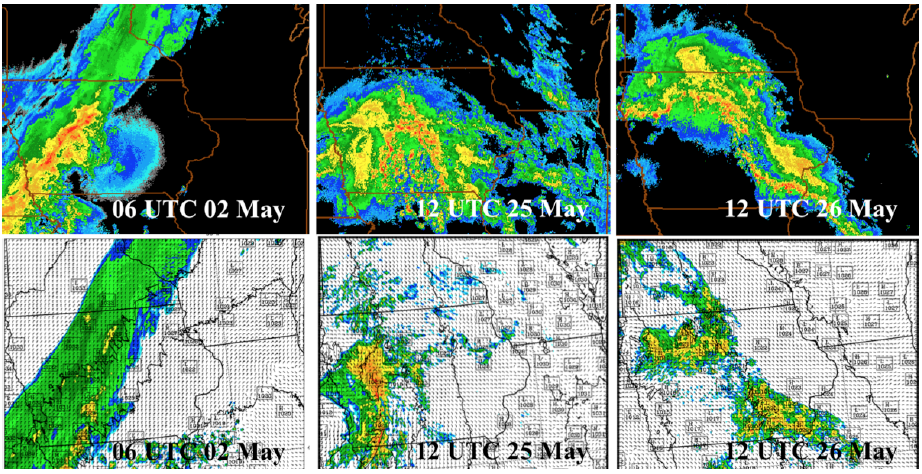
and forecast by the NU-WRF model (below) for IFloodS.
Supporting broader IPHEx objectives, NU-WRF and other U.S. modeling groups continue assessing their forecasts as well as sharing model output. In turn, the NU-WRF team is benefitting from the collected IFloodS and IPHEx datasets by using them to validate and ultimately improve the model.
Jarrett Cohen NASA Goddard Space Flight Center
ContactsDi WuResearch Associate Mesoscale Atmospheric Processes Laboratory NASA Goddard Space Flight Center/SSAI di.wu@nasa.gov 301.614.5703 |
Wei-Kuo Tao Senior Research Scientist Mesoscale Atmospheric Processes Laboratory NASA Goddard Space Flight Center wei-kuo.tao-1@nasa.gov 301.614.6269 |
|
|
Christa Peters-Lidard Physical Scientist Hydrological Sciences Laboratory NASA Goddard Space Flight Center christa.d.peters-lidard@nasa.gov 301.614.5811 |
Dan Duffy High-Performance Computing Lead NASA Center for Climate Simulation NASA Goddard Space Flight Center daniel.q.duffy@nasa.gov 301.286.8830 |
|
More Information | ||
|
Integrated Precipitation and Hydrology Experiment
Iowa Flood Studies |
NASA-Unified Weather Research and Forecasting | |