Key Global Model Forecast and Reanalysis Data
Boost NASA Planetary Missions
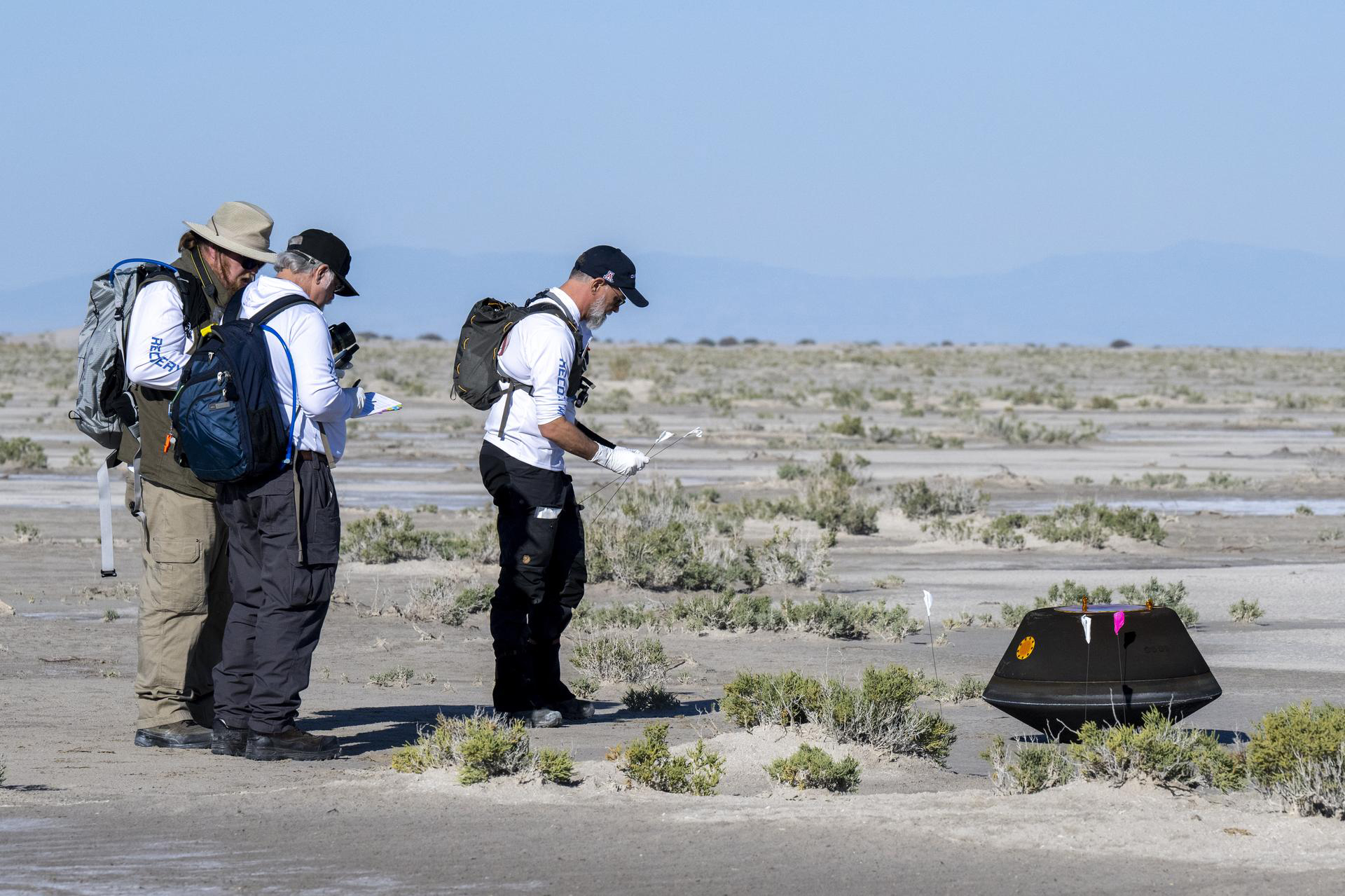
From left to right, NASA Astromaterials Curator Francis McCubbin, NASA Sample Return Capsule Science Lead Scott Sandford, and University of Arizona OSIRIS-REx Principal Investigator Dante Lauretta collect science data, Sunday, September 24, 2023, shortly after the sample return capsule from NASA’s OSIRIS-REx mission landed at the Department of Defense’s Utah Test and Training Range. The sample was collected from the asteroid Bennu in October 2020 by NASA’s OSIRIS-REx spacecraft. Global Modeling and Assimilation Office (GMAO) forecast data generated on a NASA supercomputer supported the reentry and preparatory tests. Photo by NASA/Keegan Barber.
From the Mars 2020 Perseverance Rover, to OSIRIS-REx asteroid sample return, to the future Dragonfly rotorcraft going to Saturn’s moon Titan, NASA Goddard Space Flight Center’s Global Modeling and Assimilation Office (GMAO) and the NASA Scientific Computing Project's1 high-performance computing resources have been providing key weather forecast and reanalysis data to boost multiple NASA planetary missions in recent years.
“Decelerating a vehicle is crucial for a successful landing on a planet with a low-density atmosphere such as Mars,” said Lawrence Coy, GMAO lead research scientist. “The low air density on the Martian surface is similar to densities of the Earth’s stratosphere, making stratospheric testing ideal. NASA’s mission design and test efforts depend on the high quality of the upper atmosphere meteorology found in the GMAO’s data products.”
The GMAO tailors these data products for planetary mission customers at NASA Ames Research Center, NASA Goddard Space Flight Center, NASA Jet Propulsion Laboratory, and NASA Langley Research Center. Stratospheric testing for planetary missions happens at sites across the United States using a variety of launch vehicles. Supported testing campaigns include the following:
| Campaign Name | NASA Planetary Mission(s) | Testing Location |
|---|---|---|
| ADEPT Adaptable Deployable Entry and Placement Technology (Umbrella) |
Multiple Mission Concepts | White Sands, New Mexico |
| ASPIRE Advanced Supersonic Parachute Inflation Research Experiment |
Mars 2020 Perseverance Rover | NASA Wallops Flight Facility, Virginia |
| LOFTID Low-Earth Orbit Flight Test of an Inflatable Decelerator |
Future Mars Human Lander | Vandenberg Space Force Base, California |
| ASPIRE-2 Advanced Supersonic Parachute Inflation Research Experiment-2 |
Mars Sample Return (MSR) | NASA Wallops Flight Facility, Virginia |
| OSIRIS-REx Origins, Spectral Interpretation, Resource Identification, and Security – Regolith Explorer |
OSIRIS-REx Asteroid Sample Return | Department of Defense's Utah Test and Training Range, Utah |
| SPEED Stratospheric Projectile Experiment of Entry Dynamics |
MSR, Dragonfly (Titan) | White Sands, New Mexico |
| MSR Earth Entry System | MSR | Utah |
These campaigns all need to understand atmospheric conditions at the testing sites. Enter the GMAO’s Goddard Earth Observing System (GEOS) model, which mathematically represents the global atmosphere from the surface up to ~80 kilometers (km) — reaching through the stratosphere and beyond. GEOS runs daily at the NASA Scientific Computing Project’s NASA Center for Climate Simulation (NCCS).
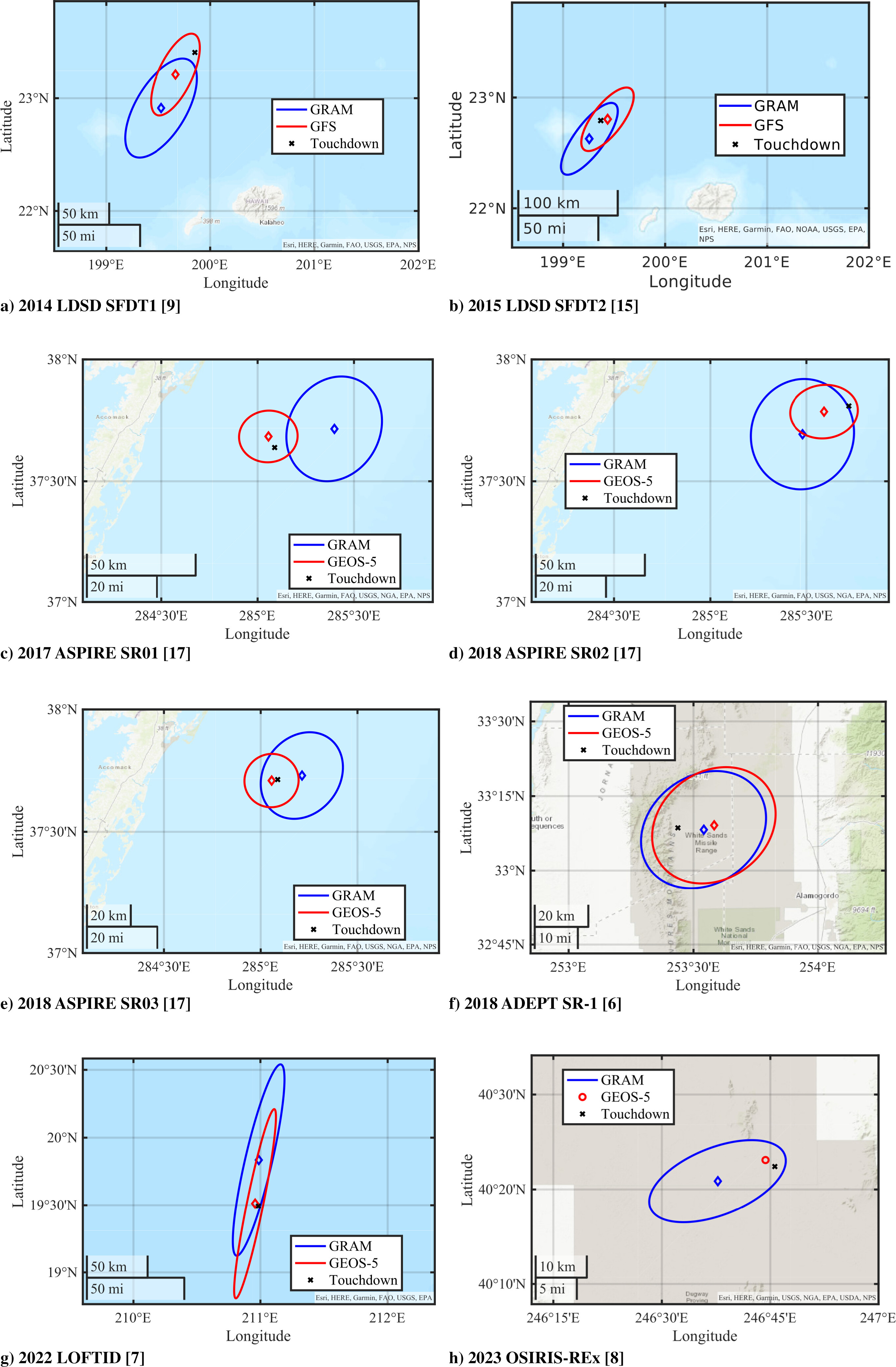
Landing ellipses for several NASA planetary missions based on the Global Reference Atmosphere Model (GRAM) and the Goddard Earth Observing System (GEOS) forecast model. Figure by Soumyo Dutta, NASA Langley Research Center, and published in Dutta, S., 2025.
As part of a longtime partnership, GMAO and NCCS provide three GEOS data products to planetary mission testing campaigns:
| Site-Specific Climatology | Site-Specific Forecast Error Estimates | Site-Specific Forecasts |
|---|---|---|
| Wind, Temperature, Density Profiles | Wind, Temperature, Density | Wind, Temperature, Density |
| Means and Variability | 24- and 48-hour forecast error profiles | 24- and 48-hour forecasts |
|
MERRA-2 reanalysis (1980–Present) |
Recent GEOS-FP Near-Real-Time Forecasts | GEOS-FP Near-Real-Time Forecasts |
The Modern-Era Retrospective analysis for Research and Applications, Version 2 (MERRA-2) is a reanalysis that assimilates all available observational data from 1980 (the beginning of the satellite era) to the present. For MERRA-2, the GEOS model runs at 50-km horizontal resolution on the NCCS Discover supercomputer. The initial 40 years of MERRA-2 took 21,915 computing hours across four streams using 184 processor cores each. MERRA-2 continues assimilating data daily.
GEOS-Forward Processing (GEOS-FP) runs four times per day at 12-km resolution using as many as 10,000 cores on Discover. GEOS-FP assimilates the latest observations available to enable the most realistic starting conditions for each forecast run.
GMAO researchers provide the MERRA-2 and GEOS-FP data products through the NCCS DataPortal and NCCS-hosted FLUID system.
“The NCCS Discover and DataPortal teams work closely with GMAO to ensure that resources are available to support both sub-orbital and orbital missions,” said Robert Lucchesi, GMAO scientific programmer. “The compute- and I/O-intensive GEOS-FP system requires priority access to thousands of high-performance cores on Discover to generate these products at the short latencies needed for mission support. Moreover, the integration of Discover and DataPortal storage systems allows efficient export of large datasets to support this work.”
Impact: NASA planetary missions must rely on deceleration testing in Earth’s stratosphere to mimic landing conditions in low-density planetary atmospheres such as Mars. For reentry, the GMAO’s altitude extent — from the surface to ~80 kilometers — provides readily available climatology and forecasts for landing location prediction.
Learn more about three supported planetary mission testing campaigns by clicking on the buttons below.
LOFTID (Low-Earth Orbit Flight Test of an Inflatable Decelerator) is demonstrating large aeroshell — 6 meters in diameter or about 20 feet — entry from low-Earth orbit in conditions relevant to many potential applications, including a future Mars Human Lander.
The LOFTID reentry vehicle launched November 10, 2022, aboard a United Launch Alliance Atlas V as a secondary payload with the Joint Polar Satellite System-2 (JPSS-2), a polar-orbiting weather satellite. After JPSS-2 reached orbit, LOFTID was put on a reentry trajectory from low-Earth orbit to demonstrate the inflatable aeroshell or heat shield’s ability to slow down and survive re-entry. The GMAO data products supported the design and characterization of the reentry environment.

As LOFTID reentered Earth’s atmosphere and reached nearly 2,700 degrees Fahrenheit, the extreme heat caused gases around it to ionize and form plasma. On the right, the images from the center body cameras became extremely bright in the visible spectrum, while the Earth is visible on infrared cameras as the vehicle rotated. Animation by NASA.
On launch day, Soumyo Dutta, aerospace engineer, Atmospheric Flight and Entry Systems Branch, NASA Langley, wrote the GMAO team: “Thank you so much for your help! This is unofficial, but the actual vehicle splashdown was within 5 nautical miles of the predicted spot, which is thanks a lot in part to the GEOS prediction. It was great working with you on another flight project.”
The OSIRIS-REx (Origins, Spectral Interpretation, Resource Identification, and Security – Regolith Explorer) mission was to collect an asteroid sample and deliver it to Earth. The spacecraft successfully collected a sample from the asteroid Bennu on October 20, 2020. After additional flyovers of Bennu, OSIRIS-REx began its long journey back to Earth on May 10, 2021. The GMAO provided weather forecasts in support of sample capsule reentry tests as well as the capsule reentry itself on September 24, 2023. GMAO researchers also continued to provide climate information for the post-descent evaluation.
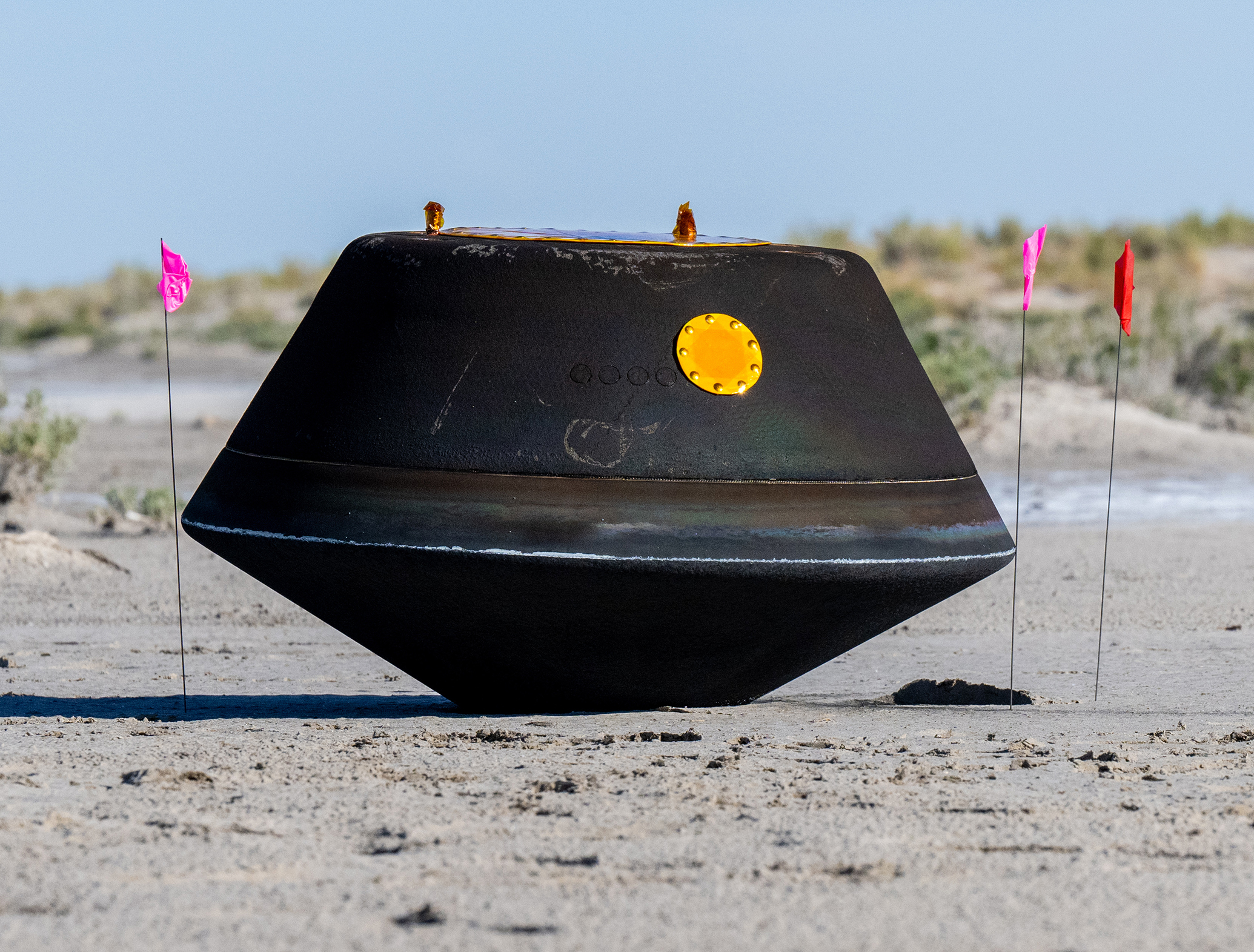
The sample return capsule from NASA’s OSIRIS-REx mission is seen shortly after touching down in the desert on Sunday, September 24, 2023, at the Department of Defense's Utah Test and Training Range. Photo by NASA/Keegan Barber.
Two NASA Langley researchers wrote the GMAO team about the success of the reentry tests:
“No sir, no issues at all. In fact, our simulation with the final weather predict did remarkably well,” wrote Anthony Williams, research computer scientist, Atmospheric Flight and Entry Systems Branch, NASA Langley.
“For OSIRIS-REx we had really good success using the forecast atmosphere; we landed unofficially ~2.2 km of the prediction from GEOS,” wrote Soumyo Dutta, aerospace engineer, Atmospheric Flight and Entry Systems Branch, NASA Langley.
SPEED (Stratospheric Projectile Experiment of Entry Dynamics) is an ongoing effort that “leverages a stratospheric balloon and 3D-printed flight system in a novel two-stage configuration to deliver test articles to supersonic conditions in the atmosphere” to capture critical vehicle dynamics behaviors that cannot be measured in ground test facilities. The project was developed over two years at NASA Ames. The inaugural flight of the SPEED test platform is scheduled for August 2025, testing scaled capsules of the Mars Sample Return (MSR) Earth Entry System and the Dragonfly (a rotorcraft that will explore Saturn's moon Titan) entry vehicle. For SPEED, the GMAO provides both MERRA-2 and GEOS-FP data products to assess landing ellipses for the test capsules for hazard analysis and recovery support.
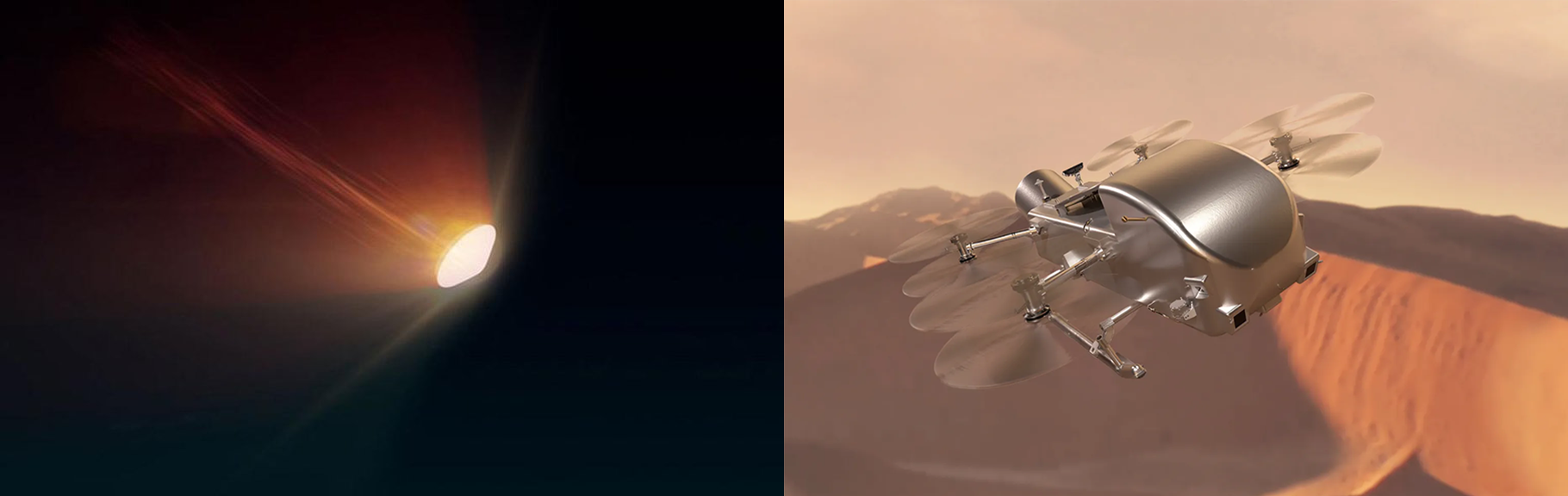
The illustrations depict the Mars Earth Entry System for the Mars Sample Return campaign entering Earth’s atmosphere (left) and the Dragonfly rotorcraft flying over the dunes of Saturn’s moon Titan (right). Illustrations by NASA/JPL-Caltech and NASA/Johns Hopkins APL/Steve Gribben.
Cole Kazemba, Dragonfly EDL System Engineer, Entry Systems and Vehicle Development Branch, NASA Ames, wrote the GMAO team in appreciation: “We have been singing the praises of you and your office whenever we discuss this because of how valuable this data is and how great it has been working with you. Thanks again for your collaboration here.”
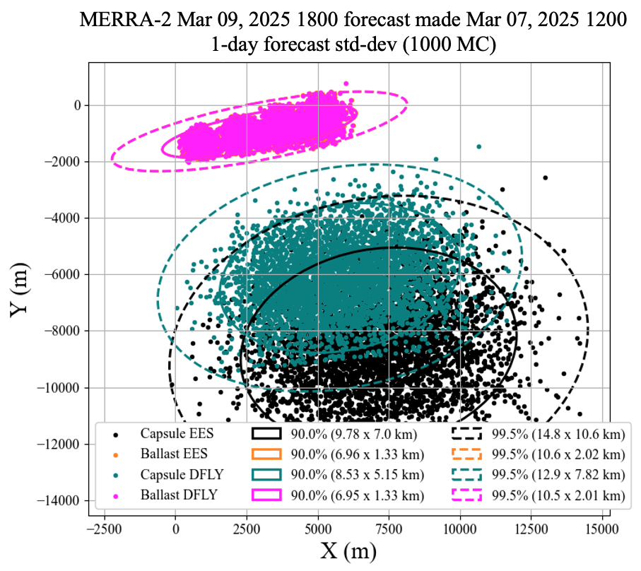
Based on NASA MERRA-2 data, the SPEED team produced these plots where winds and forecast uncertainty drive the landing ellipse size and center for the Dragonfly mission. The simulation starts the vehicles at (X, Y) = (0, 0), where 16 bodies (x8 capsules – x4 EES in black, x4 DFLY in teal, x8 ballasts – x4 EES in orange, and x4 DFLY in magenta) are shown with 1,000-case Monte-Carlo points each. Figure by Quincy McKown, NASA Ames Research Center.
Related Links
- Global Modeling and Assimilation Office (GMAO): NASA Field Campaigns Supported by GMAO.
- Dutta, S., 2025: “Use of Forecast Atmospheric Data for Earth Entry, Descent, and Landing Missions.” Journal of Spacecraft and Rockets, 62, no. 2, 687–691, doi:10.2514/1.A36119.
- “Weather Forecasts Support Rocket Launches Testing Parachutes for Mars Missions,” NCCS Highlight, October 30, 2018.
Jarrett Cohen, Lawrence Coy, Christine Bloecker, and Robert Lucchesi, NASA Goddard Space Flight Center
July 24, 2025
1 NASA Scientific Computing Project capabilities include the NASA Center for Climate Simulation (NCCS), a high-performance computing center at NASA Goddard Space Flight Center.↩