NCCS and NOAA Supercomputers Help Scientists Quantify the Components of Land Water Evaporation
Using NASA Center for Climate Simulation (NCCS) and National Oceanic and Atmospheric Administration (NOAA) supercomputers, NASA scientists ran multi-decade land surface model simulations to investigate uncertainties in quantifying the components of terrestrial evaporation (ET)—the amount of water that evaporates from land to atmosphere. ET is a key factor in determining how much water is available on land for agriculture and other purposes.
The scientists ran seven simulations of the continental U.S. at ~12.5-kilometer resolution, each using a different North American Land Data Assimilation System (NLDAS) model. Four operational runs were at NOAA. The three runs at NCCS each spanned 30+ years, with additional spin-up of 60 years.
The NCCS runs used 256 to 512 processors (3,584 to 7,168 cores) on the Discover supercomputer and took a few days to a few weeks to complete.
Discover’s online disk housed 1.5 terabytes of NLDAS-2 meteorology input data as well as 750 gigabytes of model output, which the scientists analyzed using software tools (e.g., MATLAB, IDL) installed on Discover.
The simulations show that there are big disagreements among the models in how they compute ET’s three components: plant evaporation, soil evaporation, and intercepted water (leaf canopy) evaporation.
Further analysis sought to identify the key sources of uncertainties, looking at both how the models distribute ET across the continental U.S. and—advancing most prior studies—how they partition ET into its three components.
The analysis shows that uncertainty in regional distribution of ET exaggerates differences in continental-scale ET partitioning by the land surface models.
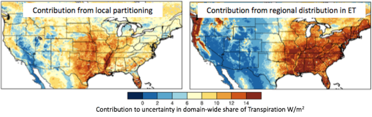
Simulations run at NCCS and NOAA show large variation in how seven land surface models compute and partition the components of terrestrial evaporation. Uncertainty in local partitioning (left) can only partly explain these differences. Analysis shows that uncertainty in regional distribution of ET (right) combines with the uncertainty in evaporation pathway to exaggerate differences in continental-scale ET partitioning.
These results can improve understanding of carbon and water cycle links, as well as guide enhancements to land surface modeling and data assimilation.
“NASA supercomputing resources have been critical in enabling these simulations in a timely manner,” said Sujay Kumar, research physical scientist in NASA Goddard Space Flight Center’s Hydrological Sciences Laboratory. “The operational NLDAS at NOAA runs serially, which requires several months for the model runs—from 1979 to present. The Land Information System environment at NCCS can complete this run in 4 days. For research studies that require multiple such runs, the availability of NCCS resources is vital.”
More Information
Kumar, S.V., T. Holmes, D.M. Mocko, S. Wang, and C.D. Peters-Lidard, 2018: Attribution of Flux Partitioning Variations Between Land Surface Models Over the Continental U.S., Remote Sensing, 10(5), 751, doi:10.3390/rs10050751.