NASA Supercomputer Enables Seasonal Forecasts
for High Mountain Asia
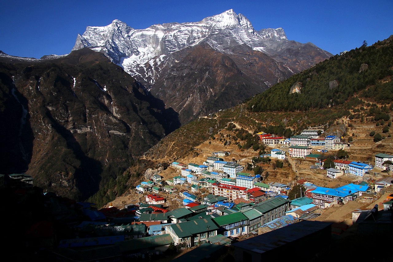
The town Namche Bazaar sits at 3,440 meters (11,286 feet) in the Khumbu area of northeastern Nepal, within the Himalayas. In the background is the mountain Kongde Ri, with its summit at 6,187 meters (20,299 feet). Namche Bazaar is a trading hub and home to many Sherpas who serve as visitor guides. A recent study enabled by NASA supercomputers produced seasonal forecasts of atmospheric and land surface conditions for Nepal and other countries across the High Mountain Asia region. Photo by Guillaume Baviere from Uppsala, Sweden, CC BY-SA 2.0, via Wikimedia Commons.
Using forecasts run on a NASA supercomputer, scientists from Oak Ridge National Laboratory (ORNL); NASA Goddard Space Flight Center; the University of California, Berkeley; and the Korea National University of Transportation assessed the ability of NASA’s Goddard Earth Observing System Subseasonal to Seasonal Version 2 (GEOS-S2S-2) forecasting system to predict atmospheric and land surface conditions throughout the High Mountain Asia region.
High Mountain Asia covers parts of China, Afghanistan, Pakistan, Nepal, Bhutan, India, Bangladesh, Myanmar, Kazakhstan, Uzbekistan, Kyrgyzstan, and Tajikistan. The region stretches across several mountain ranges, including the Himalayas, Inner Tibetan Plateau, Karakoram, and Hindu Kush. These mountains funnel fresh water into major river basins that supply drinking water, irrigation, and hydropower for approximately 1.5 billion people — more than one-seventh of the world’s population. The area also has high concentrations of snow and glacier ice.
“Across the High Mountain Asia region, seasonal variability of the hydrologic cycle directly impacts human activities, including hazard assessment and mitigation, agricultural decisions, and water resources management,” said Elias Massoud, a Computational Ecohydrologist in ORNL’s Computational Sciences and Engineering Division. “This study provides a benchmark of the seasonal forecasting skill for many variables relevant to water resources management and hazard mitigation.”
Massoud served as lead author on the study, which was recently published in the journal Earth System Dynamics. At the time of the computations, Massoud was working as a Postdoctoral Researcher in the University of California, Berkeley’s Department of Environmental Science, Policy, and Management.

Computational study authors include (left to right) Elias Massoud of Oak Ridge National Laboratory, Lauren Andrews of NASA Goddard Space Flight Center, and Manuela Girotto of the University of California, Berkeley.
“S2S forecasting is generally challenging since our ability to make accurate forecasts degrades at 10 days to 2 weeks,” Massoud explained. “What further exacerbates the difficulties of S2S forecasting for the High Mountain Asia region is the extremely complex terrain and topographical variability, which makes it challenging to both observe and model this region with high precision.”
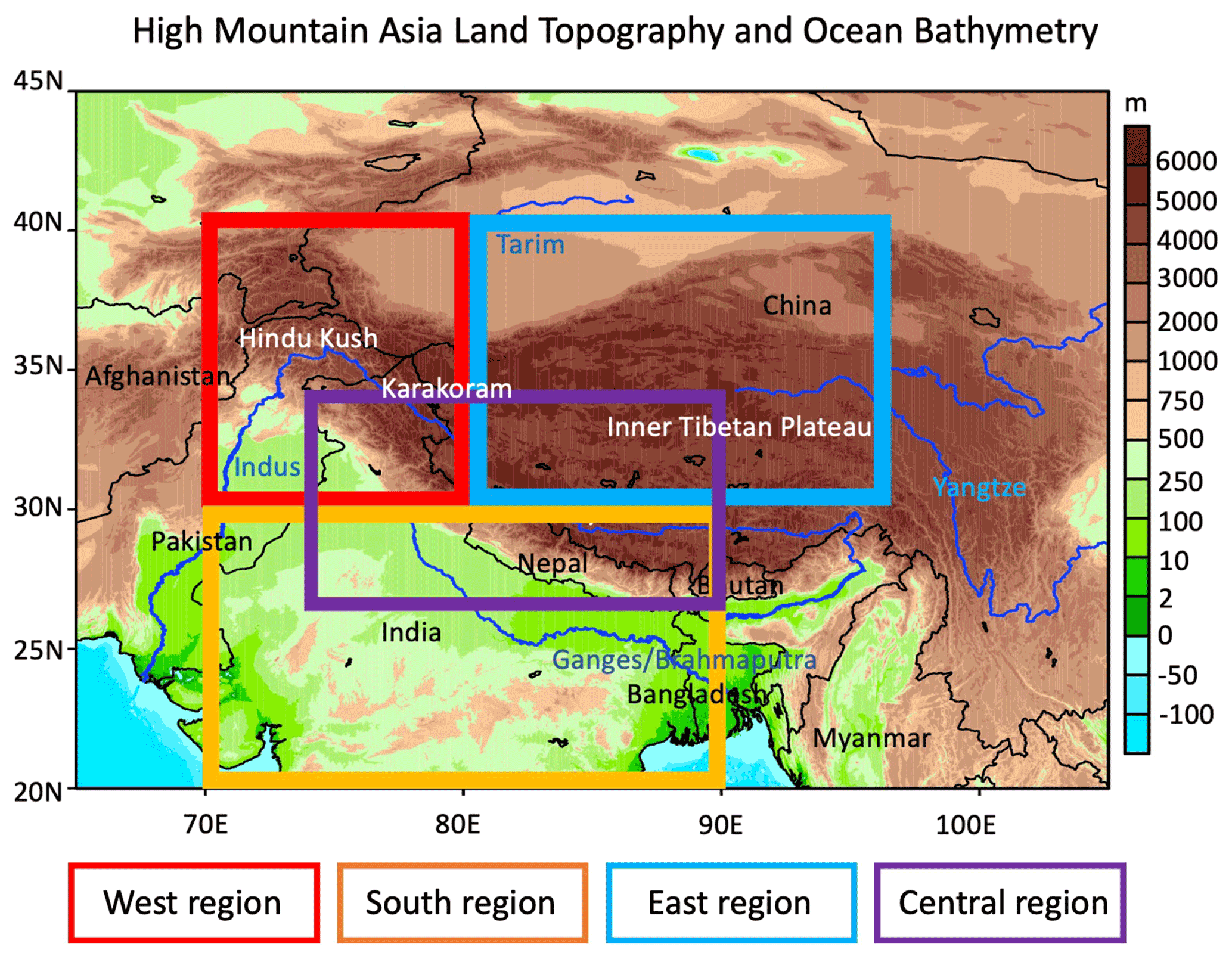
This map shows High Mountain Asia topography (elevation in meters) and ocean bathymetry using the NOAA National Geophysical Data Center's ETOPO1 global relief model. Countries are in black text, mountain ranges are in white text, and major basin rivers are in blue text. With different topography, population density, and climate across High Mountain Asia, the researchers divided the area into four subregions. The west region shown in red includes the Hindu Kush and Karakoram mountains, the south region includes the Indian subcontinent, the east region includes the Inner Tibetan Plateau, and the central region includes the Himalayas. Figure from Massoud et al., 2023.
GEOS-S2S-2 is a global modeling and forecasting system developed and maintained by NASA Goddard’s Global Modeling and Assimilation Office (GMAO). It incorporates atmosphere, ocean, land surface, and sea ice models running at .5-degree grid resolution (111 kilometers/69 miles at the equator) and ocean and atmosphere-ocean data assimilation systems that ingest observational data every 6 hours. GEOS-S2S-2 produces forecasts in 5-day segments.
The study team ran GEOS-S2S-2 on the NASA Center for Climate Simulation (NCCS) Discover supercomputer. The retrospective forecast period (1981–2016) consisted of monthly 4-member ensemble forecasts with a 9-month duration; the production period (2017–present) had 10-member ensemble forecasts of the same frequency and duration. Each 9-month forecast harnessed 384 processor cores and required 54 hours of compute time. Model outputs are stored on Discover online disk and the NCCS DataPortal.
“The complexity of the GEOS-S2S system, the use of NASA and other observations, and the number of ensemble members completed each month all improve our ability to produce skillful S2S forecasts,“ said Lauren Andrews, Research Physical Scientist in NASA Goddard’s GMAO. “NASA supercomputing resources are critical to run the system and produce forecasts in time with the resolution and outputs needed.”
As described in the video, Asia’s high mountains are a crucial freshwater source to more than one-seventh of the world’s population. Rapid changes in the region’s climate are affecting glacier flows and snowmelt. Video by NASA's Goddard Space Flight Center (Animator: Bailee DesRocher, USRA; Writer: Carol Rasmussen, NASA/JPL Caltech; and Producer: Katie Jepson, KBRwyle).
The researchers evaluated skill for 1-, 2-, and 3-month forecasts against many information sources including reanalysis data (for example, GMAO’s MERRA-2), satellite data (for example, NASA’s MODIS and GRACE), and other blended data products. “Utilizing different sources of information is critical for thoroughly addressing the uncertainty of the evaluation results,” Massoud said.
For the High Mountain Asia study, the scientists focused on GEOS-S2S-2 forecast variables that are relevant to the region’s hydrometeorology: 2-meter air temperature, total precipitation, fractional snow cover, snow water equivalent, surface soil moisture, and terrestrial water storage.
Impact: Benchmarking GEOS-S2S-2 seasonal prediction skill for the High Mountain Asia region improves the prediction system by pinpointing what processes can benefit from improved model representation and/or observable information. Furthermore, the results indicate to stakeholders where in the region and for what lead times certain forecasts can be trusted and employed for water resources management and/or hazard mitigation.
Overall, “the modest levels of forecast error provide a sense of trust in the model forecasts in the context of S2S forecasting skill,” the authors wrote. Massoud said that the results showed that GEOS-S2S-2 has at least some skill when looking at the anomaly correlation statistics (scores above 0 across the board for all variables) and is better than simply guessing the mean climate of the region.
GEOS-S2S-2 showed the highest forecast skill in “long-memory” variables such as fractional snow cover, surface soil moisture, and terrestrial water storage (see next figure), particularly when compared to the MERRA-2 reanalysis (which is also based on the GEOS computer model). The forecasting system had challenges with forecasting faster-changing variables such as 2-meter air temperature and precipitation (see last figure below).
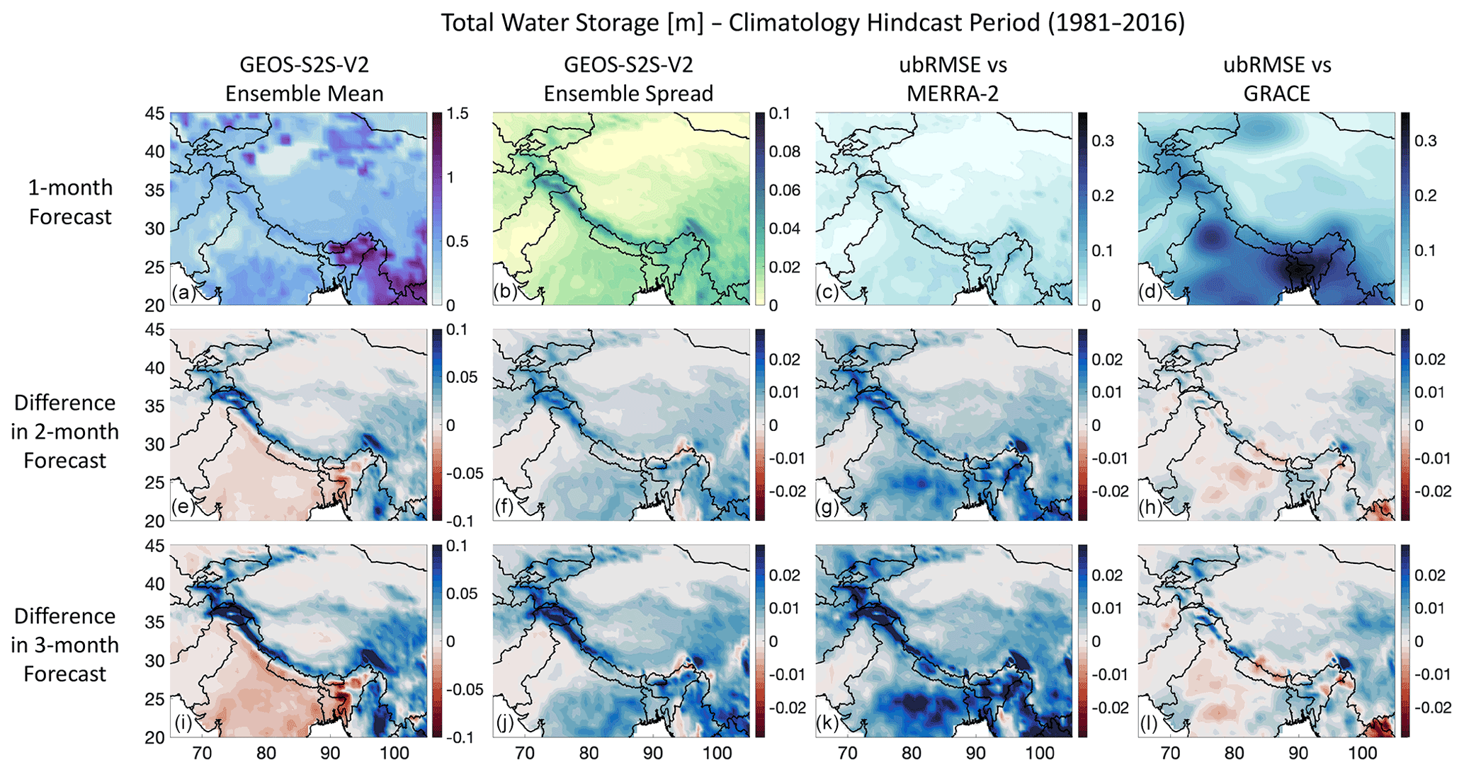
Predicted High Mountain Asia terrestrial water storage (TWS) in meters from (top to bottom) 1-, 2-, and 3-month GEOS-S2S-2 forecasts across (left to right) the 4-member forecast ensemble mean and spread and then compared with MERRA-2 and GRACE data. Red indicates lower values (i.e., less TWS, smaller spread, or smaller error), and blue indicates higher values (i.e., more TWS, larger spread, or larger error). Figure from Massoud et al., 2023.
“For forecasts with up to 3 months’ lead time, these results are somewhat surprising and indicate that subseasonal to seasonal forecasts for this region can be useful, although there is still much room for improvement,” Massoud said.
To that end, “improving forecast skill and forecast utility is a primary driver in GEOS-S2S development,” Andrews said. “As part of this project, we are working to improve the representation of the land surface during GEOS-S2S v2 assimilation, including the introduction of improved snow processes through the assimilation of MODIS snow cover fraction.”
GEOS-S2S forecasts are available to researchers and policy makers on the GMAO website in numerical and graphical formats. Continual sharing of forecast data also occurs through participation in multiple national and international multimodel ensembles, including the North American Multi-Model Ensemble. Andrews noted that the GMAO is collaborating with various groups to provide GEOS-S2S data for end users. For example, they are currently working with NASA Goddard’s Hydrological Sciences Laboratory to provide forecast data for landslide hazard prediction.
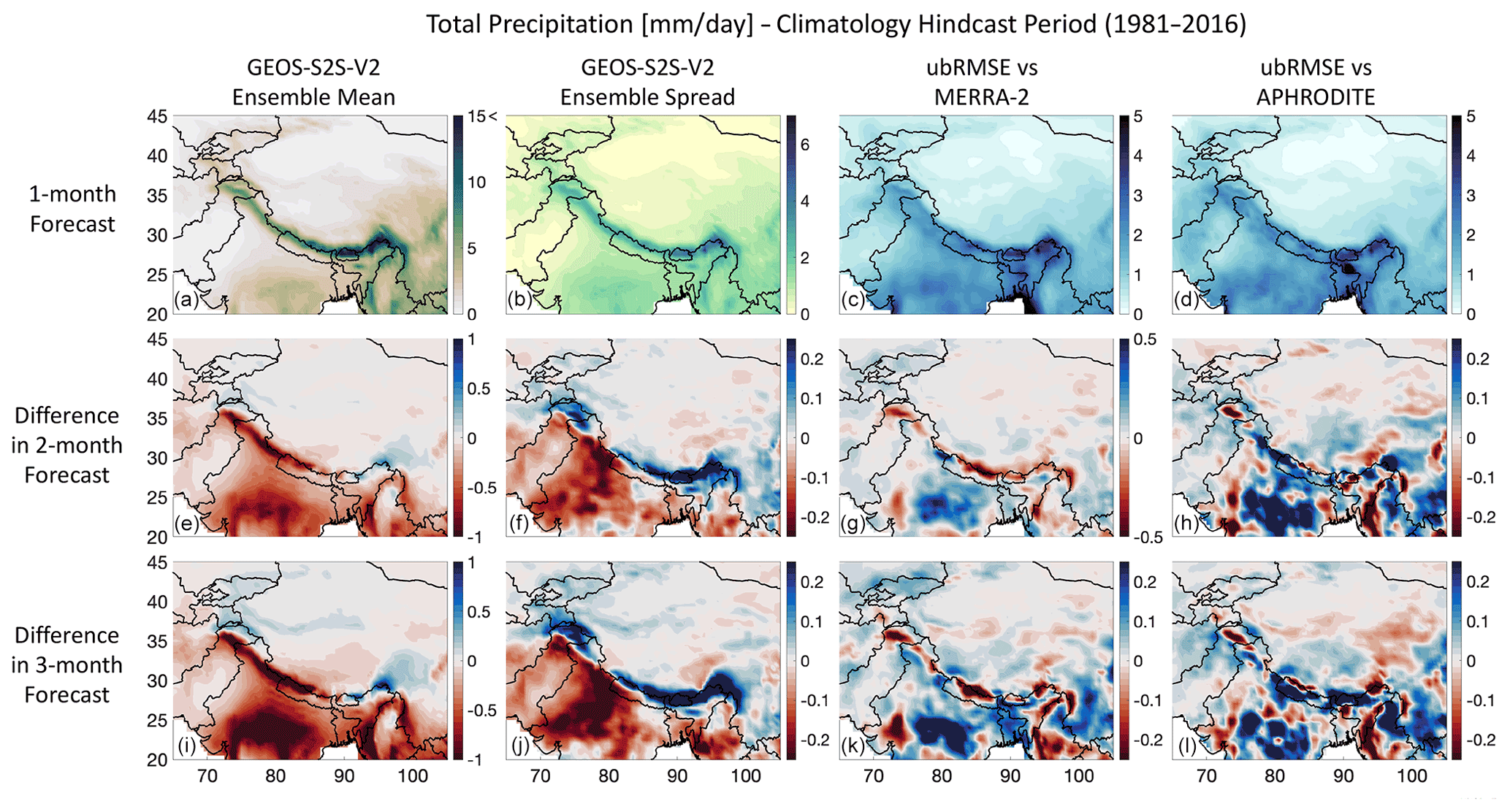
Predicted High Mountain Asia precipitation in millimeters per day from (top to bottom) 1-, 2-, and 3-month GEOS-S2S-2 forecasts across (left to right) the 4-member forecast ensemble mean and spread and then compared with MERRA-2 and APHRODITE data. Red indicates lower values (i.e., less precipitation, smaller spread, or smaller error), and blue indicates higher values (i.e., more precipitation, larger spread, or larger error). Figure from Massoud et al., 2023.
Additional study authors include Rolf Reichle and Andrea Molod of NASA Goddard’s GMAO; Jongmin Park of the Korea National University of Transportation’s Department of Environmental Engineering; and Sophie Ruehr and Manuela Girotto of the University of California, Berkeley’s Department of Environmental Science, Policy, and Management.
Related Links
- Massoud, E.C., L.C. Andrews, R.H. Reichle, A. Molod, J. Park, S. Ruehr, and M. Girotto, 2023: Seasonal Forecasting Skill for the High Mountain Asia Region in the Goddard Earth Observing System. Earth System Dynamics, 14, 147–171, doi:10.5194/esd-14-147-2023.
- Molod, A., E. Hackert, Y. Vikhliaev, B. Zhao, D. Barahona, G. Vernieres, A. Borovikov, R.M. Kovach, J. Marshak, S. Schubert, Z. Li, Y.-K. Lim, L.C. Andrews, R. Cullather, R. Koster, D. Achuthavarier, J. Carton, L. Coy, J.L.M. Freire, K.M. Longo, K. Nakada, and S. Pawson, 2020: GEOS-S2S Version 2: The GMAO High Resolution Coupled Model and Assimilation System for Seasonal Prediction. J. Geophy. Res. - Atmos., 125, doi: 10.1029/2019JD031767.
- “Upgrade Markedly Improves Skill of NASA Seasonal Prediction System,” NCCS Highlight, May 15, 2020.
Jarrett Cohen, NASA Goddard Space Flight Center
May 31, 2023