NCCS User Spotlight: Goutam Konapala
As part of NASA’s celebration of Asian American and Native Hawaiian Pacific Islander Heritage Month, this spotlight shines on NASA Center for Climate Simulation (NCCS) user Goutam Konapala. We follow Konapala from his childhood in an Indian village to his computational research on Earth’s water cycle with NASA Goddard Space Flight Center’s Biospheric Sciences Laboratory and the University of Maryland, Baltimore County (UMBC).
Hometown: I spent most of my childhood in a village near Srikakulam, Andhra Pradesh, India.

Goutam Konapala
Career path: I completed my bachelor’s degree in civil engineering at the Indian Institute of Technology, Bhubaneswar. After graduation, I worked for a year in Kolkata, India, as a management consultant at one of the Big Four global accounting networks. Later, I pursued my master’s degree in water resources engineering at the Indian Institute of Technology, Bombay. Soon after completing my master’s, I came to the U.S. to pursue a Ph.D. in hydrology at Clemson University, South Carolina. Following that, I started a postdoc in the Environmental Sciences Division at Oak Ridge National Laboratory in Tennessee. My work at Oak Ridge paved the way for me to join NASA in 2020.
Current role at NASA: In my current role, I primarily work on machine learning-based modeling of Earth’s water cycle. More particularly, I have worked on flood water mapping, snow retrieval, and streamflow modeling and more recently on natural language processing for disseminating hydrologic knowledge to scientists, governments, and the public. My main research focus is to build new algorithms for the detection and retrieval of snowfall data from NASA's passive microwave satellites including AMSR2, AMSR-E, and GPM.

The maps (top, bottom left) show the location of Srikakulam, Andhra Pradesh, India, a city near the village where Konapala spent most of his childhood. Map images by Google Earth. The photo (bottom right) shows a road to a village from Ponduru in the Srikakulam District. Photo by Adityamadhav83, CC BY-SA 3.0, via Wikimedia Commons.
NCCS support of research: NCCS is a remarkable resource for all things computational! Most of my team’s research involves producing fine-scale simulations of the water cycle through a framework known as the Land information System (LIS). For this purpose, we use the high-performance computing resources available on the Discover supercomputer. For all the machine learning and deep learning projects, we heavily depend on the Explore/ADAPT Science Cloud. The best thing about GPUs in ADAPT is their unrestrictive time slots and resources.
Studying floods with deep learning and GPUs: In a first-of-a-kind study, we used Explore/ADAPT’s Prism GPU Cluster and deep learning algorithms to combine synthetic aperture radar (SAR) and optical satellite imagery for mapping surface water extent during floods. Our dataset was comprised of 446 10-meter-resolution images of 11 global flood events, downlinked from two European Space Agency (ESA) satellites — Sentinel-1 (S1) with a SAR sensor and Sentinel-2 (S2) with an optical sensor — as well as NASA Shuttle Radar Topography Mission (SRTM) elevation data.

The first-of-a-kind “deep learning” study combined data from (top, left to right) the European Space Agency’s Sentinel-1 (S1) and Sentinel-2 (S2) satellites and NASA’s Shuttle Radar Topography Mission (SRTM) for (bottom) 11 flood events around the globe.

We ran 10 deep learning experiments on Prism, using 4 NVIDIA V100 GPUs for each experiment. The U-Net convolutional neural network algorithms we used in this study incorporate spatial information. By adding that spatial context, our experiments show that combining SAR and optical data significantly increases water detection accuracy compared to traditional machine learning algorithms. These deep learning techniques open avenues to deployment with upcoming satellite missions for rapidly generating surface water extents during time-sensitive events such as floods.
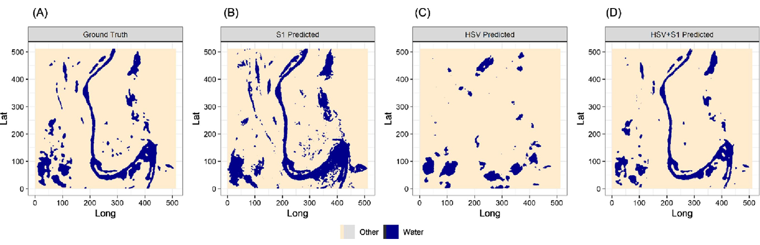
The maps show flood water extent in central Ghana, Africa (site #2 on the world map above), for (A) ground truth compared to deep learning-produced flood masks combining (B) S1 synthetic aperture radar (SAR) + SRTM elevation data; (C) S2 optical (HSV) + SRTM elevation data; and (D) a fusion of S2 optical (HSV) and S1 SAR + SRTM elevation data (using the researchers’ unique blending method). Figure adapted from Konapala et al., 2021.

Sujay Kumar
Inspiration: I love seeing my research work benefitting the research community or the public. It inspires me to do research with broad impact.
Asian Americans who have influenced me: Sujay Kumar, who is a physical scientist at NASA Goddard, is somebody I look up to for his work ethic, mentorship, and relentless optimism.
[Editor’s note: Kumar currently serves as the LIS technical lead and is a longtime NASA High-End Computing Program principal investigator and NCCS user.]

Konapala presents his research at the New Clean Water Act Meeting, Golden, Colorado, on December 21, 2019, during his postdoc at Oak Ridge National Laboratory.
Related Link
- Konapala, G., S.V. Kumar, and S. Khalique Ahmad, 2021: Exploring Sentinel-1 and Sentinel-2 Diversity for Flood Inundation Mapping Using Deep Learning. ISPRS Journal of Photogrammetry and Remote Sensing, 180, 163–173, doi:10.1016/j.isprsjprs.2021.08.016.
Jarrett Cohen, NASA Goddard Space Flight Center
May 25, 2022