July 17, 2014
Accelerating Water Map-Making for the ABoVE Field Campaign
With climate change occurring faster than anywhere else on Earth, the Arctic and nearby boreal regions greatly interest scientists. NASA and partners are mounting an 8- to 10-year field campaign to better understand how vulnerable or resilient ecosystems and society are to environmental change. This Arctic Boreal Vulnerability Experiment (ABoVE) will use coordinated satellite, airborne, and in situ observations to focus on Alaska and western Canada.
A key aspect of any ecosystem is surface water. Lakes, rivers, streams, and other water sources transport nutrients, supply habitats for flora and fauna, and affect surface energy exchange. For the ABoVE study region water is one of the least characterized features, so field campaign preparations include building comprehensive surface water maps.
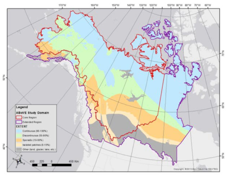
study domain focuses on Alaska and western Canada.
The best global water map assembles data from NASA’s Shuttle Radar Topography Mission and MODIS instrument onboard the Terra and Aqua satellites. The 250-meter resolution product captures larger lakes but misses smaller ones. To fill this crucial gap, NASA’s Terrestrial Ecology Program funded a pre-ABoVE mapping effort using 30-meter resolution data from Landsat satellites, which can see 20 percent more lakes in the study region.
ABoVE researchers also need to understand water dynamics, which can change rapidly. Thus, their maps consider three epochs: 1990–1992, 2000–2002, and 2010–2012. Covering ABoVE’s vast study domain for these years requires processing more than 100,000 Landsat scenes.
The original data processing plan to employ a group of workstations and an attached 8-terabyte-disk farm would have taken 9 to 12 months, leaving no time for reprocessing. Instead, the researchers turned to the new Science Cloud from the Computational and Information Sciences and Technology Office (CISTO) at NASA Goddard Space Flight Center.
The Science Cloud is a joint effort of CISTO’s NASA Center for Climate Simulation and Climate Model Data Services group. Focusing on “compute over data,” it surrounds a large amount of data storage with a high-performance compute cloud. By this fall, the Science Cloud will offer 2 petabytes of storage and 960 computer processor-cores. Per Mark McInerney, CISTO Data Services Manager, advantages to NASA over using commodity clouds include near-high-end computing levels of performance and a virtual machine (VM) environment where “we can stand up or pull down VMs as needed for specific science projects.”
By corralling up to 48 VMs for parallel data processing, pre-ABoVE researchers were able to apply their decision tree classification and other routines to the Landsat scenes and produce a seamless surface water map—all in a mere 6 weeks.
“That speed-up allowed us to expand the geographic area to most of Canada,” said Mark Carroll, a Senior Support Scientist at NASA Goddard. “In a follow-on project, we also will be able to expand the temporal component of the data and fill in the time periods between epochs.”
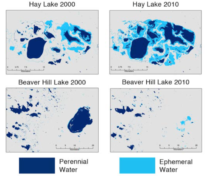
(top) and decline (bottom) of two lakes in Alberta, Canada.
Over the next several months, the mapping team will evaluate the initial results against various satellite datasets, refine their algorithm, and reprocess the data for dissemination. The final water maps will be instrumental to ABoVE campaign planners in identifying hotspots of change and pinpointing field sites for study. As ABoVE gets underway in 2015, the CISTO Science Cloud will stand ready to process the collected data.
Jarrett Cohen
NASA Goddard Space Flight Center
Research Paper
Contacts | ||
|
Mark Carroll Senior Support Scientist Biospheric Sciences Laboratory NASA Goddard Space Flight Center/ Sigma Space Corp. mark.carroll@nasa.gov 301.614.6974 |
Mark McInerney Data Services Lead Computational and Information Sciences and Technology Office NASA Goddard Space Flight Center mark.mcinerney@nasa.gov 301.286.1491 |
|
Dan Duffy High-Performance Computing Lead NASA Center for Climate Simulation NASA Goddard Space Flight Center daniel.q.duffy@nasa.gov 301.286.8830 |
||
More Information | ||
| Arctic Boreal Vulnerability Experiment | Climate Model Data Services | |