Exploring Past and Future Tropical Cyclones in the
Bay of Bengal with NASA High-End Computing
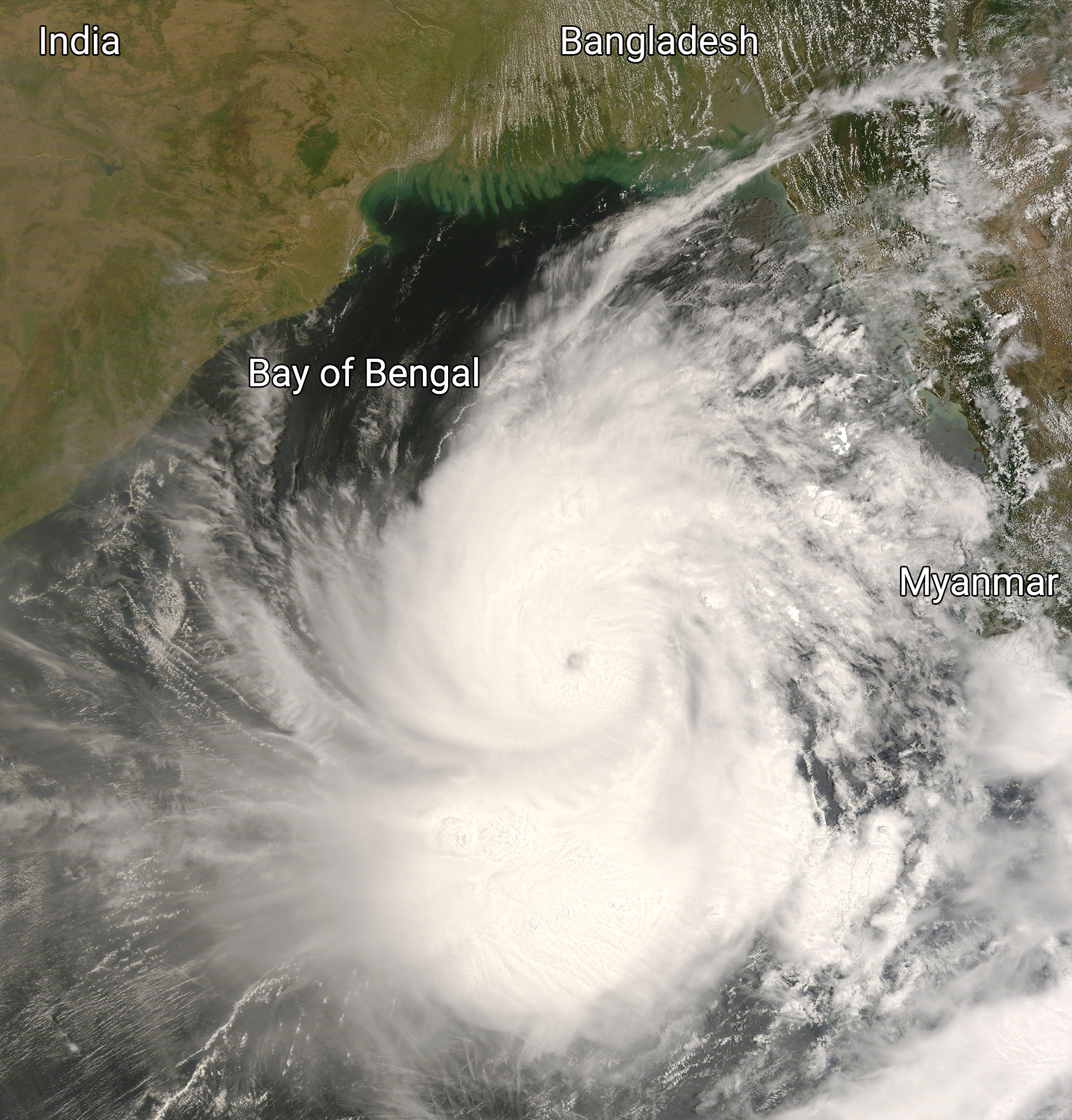
In this satellite image from May 2, 2008 (10:40 a.m. local time), the sprawling Cyclone Nargis spirals over the Bay of Bengal between India to the west and Myanmar to the east just hours before making landfall over Myanmar at 6:30 p.m. local time that day. The image comes from the Moderate Resolution Imaging Spectroradiometer (MODIS) onboard NASA’s Terra satellite. Image adapted from NASA Earth Observatory.
On April 27, 2008, one of the deadliest tropical cyclones in history formed in the central Bay of Bengal about 580 kilometers (360 miles) off the southeast coast of India. As Cyclone Nargis marched to the east-northeast it picked up strength and became a Category 4 storm with sustained winds of 210 kilometers per hour (130 miles per hour). By the evening of May 2, 2008, Nargis made landfall as a Category 3/4 storm over Myanmar’s Irrawaddy River Delta. Compounding the winds were a storm surge peaking at over 5 meters (16.4 feet) and total rainfall hitting 600 millimeters (just under 2 feet) in some areas. In its wake, Nargis caused an estimated $10 billion in damage and nearly 140,000 deaths.
The Bay of Bengal Ocean basin is notorious for generating devastating tropical cyclones, such as Nargis and the Bhola cyclone that struck Bangladesh in 1970, killing approximately 300,000 to 500,000 people. Given that Bay of Bengal cyclones are among the most destructive natural events and have created humanitarian crises multiple times, a team of NASA and university scientists undertook a study of past and future tropical cyclones in the region leveraging NASA High-End Computing resources.
“The Bay of Bengal is a region prone to frequent and intense cyclonic activity, causing significant human and economic losses,” said Abdullah Al Fahad, an Assistant Research Scientist affiliated with NASA Goddard Space Flight Center’s Global Modeling and Assimilation Office (GMAO) and the University of Maryland, College Park. “Understanding the patterns and behavior of these cyclones can aid in improving disaster preparedness and response strategies, potentially saving lives and reducing damage.”
Fahad is lead author of the study, which appears in the Journal of Climate.
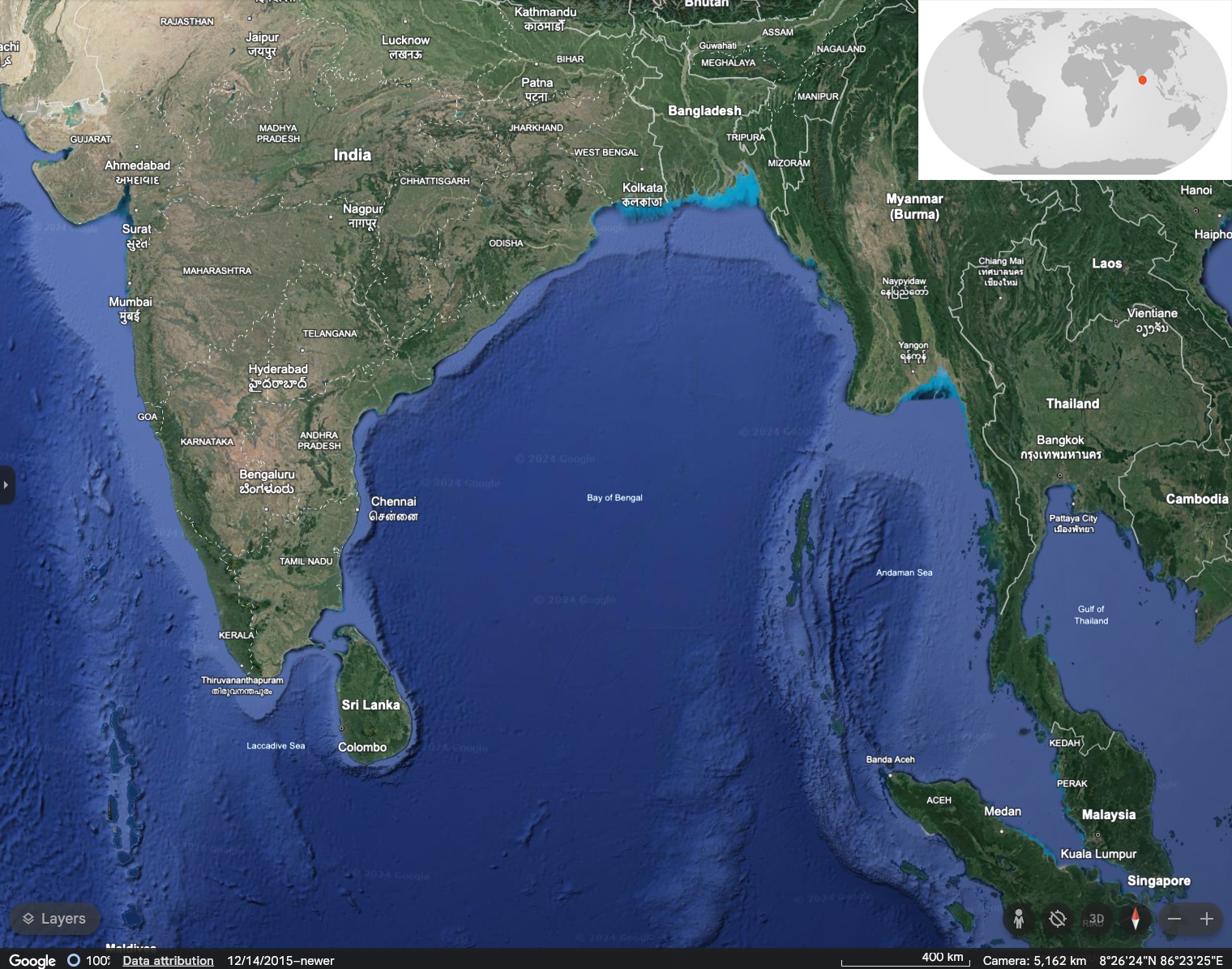
The Bay of Bengal stretches across 2,173,000 square kilometers (839,000 square miles) of the northeastern Indian Ocean. It borders Sri Lanka and India to the west, Bangladesh to the north, and Myanmar and the northern Malay Peninsula to the east. Maps by Google Earth and NASA Earth Observatory (inset world map).
“Bay of Bengal cyclones are influenced by complex interactions between ocean temperatures, atmospheric conditions, and regional climate patterns,” Fahad said. “Analyzing these factors can provide valuable insights into broader climate trends and variability.”
Such a multifaceted analysis required three datasets and NASA High-End Computing resources at the NASA Center for Climate Simulation (NCCS) and NASA Advanced Supercomputing (NAS) Facility.
The datasets capture past occurrences of Bay of Bengal tropical cyclones and related atmospheric variables as well as future predictions of cyclones’ evolution in a changing climate. See the table below for dataset names, types, and years of coverage.
| Dataset | Data Type | Years |
|---|---|---|
| International Best Track Archive for Climate Stewardship (IBTrACS) |
Observations | 1980–2021 |
| Modern-Era Reanalysis for Research and Applications, Version 2 (MERRA-2) |
Reanalysis | 1980–2021 |
| Coupled Model Intercomparison Project Phase 6 (CMIP6) |
Climate model projections | 1950–1979 2020–2049 |
These datasets include substantial NASA contributions, with the GMAO’s MERRA-2 reanalysis run at NCCS. The scientists analyzed the IBTrACS, MERRA-2, and CMIP6 datasets using front-end nodes on the NCCS Discover and NAS Pleiades supercomputers and stored 17 terabytes of output data on the supercomputers’ online disks.
“The CMIP6 high-resolution models, along with their high-temporal-resolution data, constitute a substantial dataset,” Fahad said. “NCCS and NAS support facilitated the seamless loading and analysis of this data, utilizing nodes that allowed us to simultaneously manipulate multiple model datasets. Such capabilities would have been unattainable without NASA High-End Computing resources.”
In addition to their small spatial scales, Bay of Bengal tropical cyclones are particularly difficult for global computer models to predict because of two contrasting factors affecting their formation:
- exceptionally high sea surface temperatures — the main source of energy for tropical cyclones to form.
- the “hostile” dynamical conditions caused by “vertical shear” — the change in wind velocity with height.
“Strong vertical shear generally inhibits the development of a vertically aligned rotating convective structure, which is a prerequisite for tropical cyclone formation,” said study co-author Andrea Molod, GMAO Research Physical Scientist. “However, if the shear briefly diminishes, even for half a day, the energy source over the Bay of Bengal is so powerful that a tropical cyclone can develop very quickly. Once a cyclone is formed, it is more difficult for the shear to prevail.”
Impact: The study shows that although the number of tropical cyclones is anticipated to decrease in the future due to a warming climate, more intense cyclones are expected to become prevalent in the northern Bay of Bengal during the post-monsoon season, potentially affecting Bangladesh, India, and Myanmar.
This new computational study highlighted a related, but previously overlooked, factor: the Tropical Easterly Jet (TEJ) and its intermittent nature.
The TEJ is a high-elevation, high-speed, concentrated flow of air blowing across the entire northern Indian Ocean. “When the TEJ reaches its top speed and strength during Northern Hemisphere summer’s monsoon season, it causes the strongest vertical shear of any other location in the tropics worldwide,” said study co-author Oreste Reale, Chief Scientist for Science Systems and Applications, Inc. also working with NASA Goddard’s GMAO. “However, the TEJ is subject to temporary intensity fluctuations including sudden drops in speed called ‘relaxations.’ These relaxations are very important for tropical cyclone genesis because they create a temporary favorable environment for cyclones to form.”
When combining the influences of sea surface temperatures, vertical sheer, and TEJ intermittency, the study shows that in future years through 2049 the number and energy of Bay of Bay cyclones might decrease overall while post-monsoon-season cyclones in the northern portion of the bay could increase in intensity. “Changes in the TEJ intermittency seem to be a bigger factor than just sea temperatures in a warmer climate,” Fahad noted.
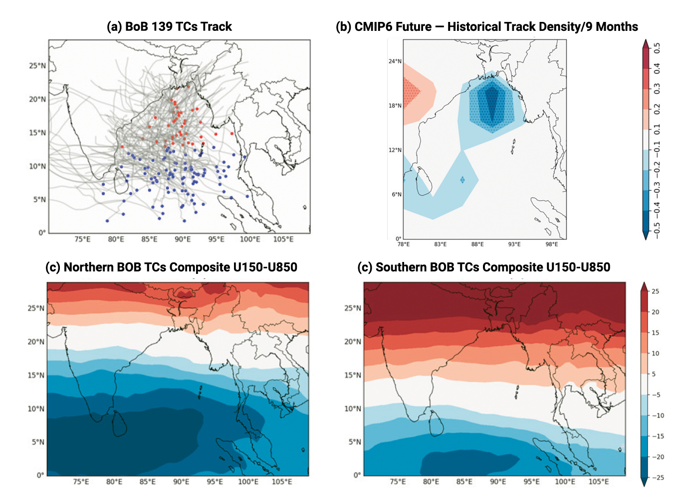
Panel (a) shows observed tropical cyclone (TC) tracks in the northern (red) and southern (blue) Bay of Bengal (BoB). Panel (b) shows the future minus historical TC track density based on CMIP6 models, indicating a clear reduction of TC activity over the northern BoB. Panels (c) and (d) show a composite analysis of MERRA-2 zonal vertical wind shear associated with the Tropical Easterly Jet (TEJ) based on TCs in the northern (c) and southern (d) BoB, indicating the connection between the TEJ and TCs where locations of low shear coincide with locations of TC development. Figures from Fahad et al., 2023.
The scientists envision future studies using the GMAO Goddard Earth Observing System Subseasonal to Seasonal Prediction System, Version 2 (GEOS-S2S-2) model output, resident at NCCS and NAS, to delve deeper into understanding the prediction skill of tropical cyclones in the Bay of Bengal and the broader Indian Ocean region.
RELATED LINKS
- Fahad, A.A., O. Reale, A. Molod, T.A. Sany, M.T. Ahammad, and D. Menemenlis, 2023: The Role of Tropical Easterly Jet on the Bay of Bengal’s Tropical Cyclones: Observed Climatology and Future Projection. Journal of Climate, 36, no. 17, doi.org/10.1175/JCLI-D-22-0804.1.
- Fritz, H., C. Blount, S. Thwin, M.K. Thu, and N. Chan, 2009: Cyclone Nargis Storm Surge in Myanmar. Nature Geoscience, 2, 448–449, doi:10.1038/ngeo558.
Jarrett Cohen, NASA Goddard Space Flight Center
February 21, 2024